With the exception of the tutorials, which use comma-separated-variable (CSV) format, the downloaded datasets are currently provided in NetCDF format only.
Available Datasets
- Dynamically downscaled climate simulations over North America (access: Thredds, RCD, FTP)
- Northwest US and Southwest Canada (access: Thredds, RCD)
- Regional Climate and Hydrologic Change (access: Thredds, RCD)
Data access via Regional Climate Downloader (RCD web application)
Data can be downloaded via the Regional Climate Downloader. For more information see the tutorial.
Data access via Thredds Data Server
Monthly average data files are currently being served by a Thredds Data Server, which provides data access via OPeNDAP, NetCDF Subset, direct link and WMS mapping. OPeNDAP provides a mechanism to stream data directly into analysis applications such as Panoply, Matlab, IDL, ferret and IDV without the need to download an entire monthly data set. Both OPeNDAP and NetCDF Subset allow data sets to subdivided by variable, time and space so that only the data of interest is downloaded, which greatly reduces the time to download and the storage required to download data sets.
Access to the Thredds data catalog can be found at:
http://regclim.coas.oregonstate.edu:8080/thredds/catalog.html
Dynamically downscaled data access via FTP
The complete monthly average data sets may be downloaded from our server via FTP. The files on the FTP are time series for each variable for the duration of the simulation (e.g., monthly average air temperature for 1968—2099).
The NetCDF files that include all variables may be downloaded from via anonymous FTP from: regclim.coas.oregonstate.edu
Daily average files are located in:
/pub/netCDF/<domain>/Daily/<model>
Monthly average files are located in:
/pub/netCDF/<domain>/Monthly/<model>
Decadal average files are located in:
/pub/netCDF/<domain>/Decadal/<model>
As an example, to get files for PNW and the NCEP run the path would be: /pub/netCDF/PNW/Monthly/NCEP.
We recommend using an FTP client rather than a browser to avoid problems that can occur with browsers.
Dynamically downscaled NetCDF file overview and naming conventions
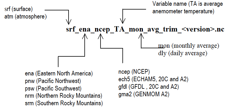
The naming convention for our simulations and their output is based on the driving GCM. The surface and near-surface variables are written into files that contain a time series of values. Metadata for the model configurations, mapping projections and included data are documented in the NetCDF files. The data are geographically registered on the Lambert Conformal projections that are used by the RegCM3 model. The naming convention for monthly average NetCDF files is:

In the file names, “trim” indicates that the raw model output files have been processed to remove the sponge boundary region around the outside of the domain and “<version>” indicates the current version of the files, which is “v5” at the time this document was written.
Time series of daily date are very large, so we have divided the daily files into decades to reduce the size of an individual file. The date range has been added to the filename in YYYYMM-YYYYMM notation. As an example the file:
srf_ena_eh5_TA_dly_avg_trim_198001-198912_v5.nc
contains daily anemometer temperature temperature for the Eastern North America domain for the periods of 1980-01-01 through 1989-12-31.
Disclaimer and Terms of Use
We have attempted to produce the highest quality model simulations based on sound experimental design and accurate processing of the model output. We have fixed any errors that we have found or that have been brought to our attention by collaborators; however, it is certain that some errors still exist. We caution that, as is the case with other climate models, there are limitations to the modeling approach and the simulations of the future actually represent climate sensitivity tests and not necessarily true projections.
All model datasets are freely available and are intended for further climate-related scientific research. Although these data have been processed successfully on a computer system at the U.S. Geological Survey (USGS), no warranty expressed or implied is made regarding the display or utility of the data on any other system, or for general or scientific purposes, nor shall the act of distribution constitute any such warranty. The USGS shall not be held liable for improper or incorrect use of the data described and/or contained herein.
